Click button below to view 360° VR interactive panorama
SD Standard definition suitable for users with slow internet connections or mobile devices or HD High definition suitable for users with fast internet connections
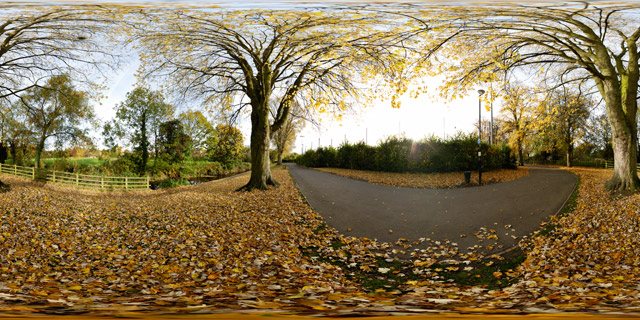
360° VR panorama of the autumn leaves carpeting the ground in part of Welland Park behind Welland Park College in Market Harborough, Leicestershire, UK. The park was originally opened in 1935 and features many attractions, including a riverside walk, tennis courts and a bowling green.

Click button below to view 360° VR interactive panorama
SD Standard definition suitable for users with slow internet connections or mobile devices or HD High definition suitable for users with fast internet connections
360° VR panorama near the south-east entrance to Welland Park in Market Harborough, Leicestershire, UK in autumn. The park was originally opened in 1935 and features many attractions, including a children’s play park, bedding displays, riverside walk.

Click button below to view 360° VR interactive panorama
SD Standard definition suitable for users with slow internet connections or mobile devices or HD High definition suitable for users with fast internet connections
360° VR panorama of the sunset over Farndon Fields in Market Harborough, Leicestershire, UK. Farndon Fields is currently (October 2010) being developed for housing by David Wilson Homes.

Click button below to view 360° VR interactive panorama
SD Standard definition suitable for users with slow internet connections or mobile devices or HD High definition suitable for users with fast internet connections
360° VR panorama of the sunset over a field just north of East Farndon, near Market Harborough, and around the border between Leicestershire and Northamptonshire, UK. The oak trees and hedge running along the edge of the field have turned yellow as the Autumn colour peaks.

Click button below to view 360° VR interactive panorama
SD Standard definition suitable for users with slow internet connections or mobile devices or HD High definition suitable for users with fast internet connections
360° VR panorama taken shortly after sunrise from the footpath across Farndon Fields in Market Harborough, Leicestershire, UK. Farndon Fields is currently (October 2010) being developed for housing by David Wilson Homes.

Click button below to view 360° VR interactive panorama
SD Standard definition suitable for users with slow internet connections or mobile devices or HD High definition suitable for users with fast internet connections
360° VR panorama of the sun rising over a frosty ploughed field on a cold October morning in Market Harborough, Leicestershire, UK.


Click button below to view 360° VR interactive panorama
SD Standard definition suitable for users with slow internet connections or mobile devices or HD High definition suitable for users with fast internet connections
360° VR panorama of a ridge and furrow field between Market Harborough and Lubenham at sunset.
From Wikipedia:
Ridge and furrow is an archaeological pattern of ridges and troughs created by a system of ploughing used in Europe during the Middle Ages. The earliest examples date to the immediate post-Roman period and the system was used until the 17th century in some areas. Ridge and furrow topography is found in Great Britain, Ireland and elsewhere in Europe. The surviving ridges are parallel, ranging from 3 to 22 yards (3 to 20 m) apart and up to 24 in (0.61 m) tall – they were much taller when in use. Older examples are often curved.
Ridge and furrow topography was a result of ploughing with non-reversible ploughs on the same strip of land each year. It is visible on land that was ploughed in the Middle Ages, but which has not been ploughed since then. No actively ploughed ridge and furrow survives.

Click button below to view 360° VR interactive panorama
SD Standard definition suitable for users with slow internet connections or mobile devices or HD High definition suitable for users with fast internet connections
360° VR panorama of the old railway line between Lubenham and Market Harborough, Leicestershire, UK.
The line, opened in 1850, ran from Rugby to Market Harborough, but was closed under the Beeching cuts of the 1960s. Today it is mainly used by dog walkers, but it can get quite waterlogged after rain.

Click button below to view 360° VR interactive panorama
SD Standard definition suitable for users with slow internet connections or mobile devices or HD High definition suitable for users with fast internet connections
360° VR panorama of an old building in a wooded area on the northeast corner of Welford reservoir. The building has been out of use for quite some time, now being overgrown with trees and daubed with graffiti. Inside the building can be seen some large tanks.
Welford Reservoir is located near the town of Welford, and provides water to the Welford arm of the Grand Union Canal.

Click button below to view 360° VR interactive panorama
SD Standard definition suitable for users with slow internet connections or mobile devices or HD High definition suitable for users with fast internet connections
360° VR panorama of All Saints Church in Lubenham, Leicestershire, UK, at sunset. Constructed of ironstone dressed with limestone, the Church consists of a chancel, clerestoried nave, north and south aisles, a north chapel, and south porch. The West tower is castellated, and it is thought that it may once have been topped with a spire.


