Click button below to view 360° VR interactive panorama
SD Standard definition suitable for users with slow internet connections or mobile devices or HD High definition suitable for users with fast internet connections
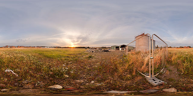
360° VR panorama by a couple of corrugated steel silos in Farndon Fields, Market Harborough, UK. Farndon Fields is currently being developed, with several developers building houses in the area. The nearby silos and barn buildings have been fenced off for demolition as part of the development.

Click button below to view 360° VR interactive panorama
SD Standard definition suitable for users with slow internet connections or mobile devices or HD High definition suitable for users with fast internet connections
360° VR panorama of flowerbed displays near the south-east entrance to Welland Park, in Market Harborough, Leicestershire, UK. The flower displays are planted by Harborough in bloom volunteers in conjunction with council workers.
The displays in Welland Park play a large part in the town’s entry to the East Midlands in Bloom competition each year.

Click button below to view 360° VR interactive panorama
SD Standard definition suitable for users with slow internet connections or mobile devices or HD High definition suitable for users with fast internet connections
360° VR panorama of a damaged, but still alive tree growing by a field of green wheat near East Farndon, Northamptonshire, England.

Click button below to view 360° VR interactive panorama
SD Standard definition suitable for users with slow internet connections or mobile devices or HD High definition suitable for users with fast internet connections
360° VR panorama of a large puddle at the end of a ditch in the north-west corner of Farndon Fields, Market Harborough, England. The River Welland runs alongside part of the field, and can sometimes cause flooding of the area.
Farndon Fields is currently under development, and the developers have built a number of flood defences, which seem to have coped well with the April rain so far. The ditch area at the north of the field shown here is probably not complete yet (since it doesn’t go anywhere).
To the north of the field is an embankment that used to carry the Rugby and Stamford Railway line. Currently it is used as pasture for a few farm animals, in this image a couple of bullocks can be seen.

Click button below to view 360° VR interactive panorama
SD Standard definition suitable for users with slow internet connections or mobile devices or HD High definition suitable for users with fast internet connections
360° VR panorama of daffodils flowering in early Spring in Welland Park, Market Harborough, England. Welland Park is a popular area of the town, with colourful flower beds visitors can admire, and a play area for children. The River Welland runs though the park, and sometimes a Kingfisher can be seen along its banks.

Click button below to view 360° VR interactive panorama
SD Standard definition suitable for users with slow internet connections or mobile devices or HD High definition suitable for users with fast internet connections
360° VR panorama of daffodils flowering in early Spring alongside the Millennium Mile footpath in Market Harborough, Leicestershire, England. The Millennium Mile route runs alongside the River Welland, going from the east of the town to the edge of Welland park in the west.
From this position, the B&M Bargains store (previously Marks & Spencers) can be seen across the river to the north, while Oaktree house sheltered accommodation is to the south.

Click button below to view 360° VR interactive panorama
SD Standard definition suitable for users with slow internet connections or mobile devices or HD High definition suitable for users with fast internet connections
360° VR panorama of tracks through the snow past a hollow tree, between the villages of Lubenham and East Farndon, England. As well as the tracks left by walkers, there are lots of rabbits tracks left in the snow.
Beyond the dead tree there is a snow covered manure heap, and a farm building.

Click button below to view 360° VR interactive panorama
SD Standard definition suitable for users with slow internet connections or mobile devices or HD High definition suitable for users with fast internet connections
360° VR panorama of the stile between two snow covered fields at the top of a hill to the north-west of East Farndon, Northamptonshire, England. Nearby is a communications mast.

Click button below to view 360° VR interactive panorama
SD Standard definition suitable for users with slow internet connections or mobile devices or HD High definition suitable for users with fast internet connections
360° VR panorama of an old rusty bathtub in a snow covered field between Lubenham and East Farndon, Northamptonshire, England. The tub is probably usually used as a cattle trough. Rabbit tracks can be seen nearby in the snow.

Click button below to view 360° VR interactive panorama
SD Standard definition suitable for users with slow internet connections or mobile devices or HD High definition suitable for users with fast internet connections
360° VR panorama of a gateway between two fields located between Lubenham and East Farndon, Northamptonshire, England. The fields are usually used as cattle pasture, though the cattle had presumably been brought into barns at the time this photo was taken due to the cold weather.
Footprints of walkers and rabbits can be seen in the snow.


