Click button below to view 360° VR interactive panorama
SD Standard definition suitable for users with slow internet connections or mobile devices or HD High definition suitable for users with fast internet connections
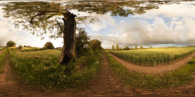
360° VR panorama of a damaged, but still alive tree growing by a field of green wheat near East Farndon, Northamptonshire, England.

Click button below to view 360° VR interactive panorama
SD Standard definition suitable for users with slow internet connections or mobile devices or HD High definition suitable for users with fast internet connections
360° VR panorama of an old rusty bathtub in a snow covered field between Lubenham and East Farndon, Northamptonshire, England. The tub is probably usually used as a cattle trough. Rabbit tracks can be seen nearby in the snow.

Click button below to view 360° VR interactive panorama
SD Standard definition suitable for users with slow internet connections or mobile devices or HD High definition suitable for users with fast internet connections
360° VR panorama by a ‘Heavy Plant Crossing’ sign placed in the middle of the footpath at the southern end of the Farndon Fields Development in Market Harborough, Leicestershire, England.
The area is currently being developed, with a number of new homes being built. Nearby in the muddy field can be seen a small section of pathway, still under construction.

Click button below to view 360° VR interactive panorama
SD Standard definition suitable for users with slow internet connections or mobile devices or HD High definition suitable for users with fast internet connections
360° VR panorama of the footpath across Farndon Fields, in Market Harborough, Leicestershire, England. The area is currently under development, with a number of new homes being built.
To the right is a small ditch, presumably cut to help drainage of the clay-heavy soil. The ground in this area is rather muddy due to the heavy machinery used in the construction work.
Not far away can be seen a pile of small trees and boxes filled with shrubs, waiting to be planted as part of the development.

Click button below to view 360° VR interactive panorama
SD Standard definition suitable for users with slow internet connections or mobile devices or HD High definition suitable for users with fast internet connections
360° VR panorama of kerbstones, tiles, and various other building supplies and equipment, at the Farndon Fields Development in Market Harborough, Leicestershire, UK.
Although development is still ongoing as at January 2012, the first few houses were completed, and some occupied, in 2011.

Click button below to view 360° VR interactive panorama
SD Standard definition suitable for users with slow internet connections or mobile devices or HD High definition suitable for users with fast internet connections
360° VR panorama of the entrance at the north-east corner of Farndon Fields, just off Rugby Close. Running around the edge of the field is an ecology fence, about 1 ft high and constructed of black plastic sheeting.
Farndon Fields is currently under development, nearby you can see a newly created pond with a fence round it. The majority of the grass growing in the field has also been planted as part of the development, replacing the mixture of wild plants that grew there previously.

Click button below to view 360° VR interactive panorama
SD Standard definition suitable for users with slow internet connections or mobile devices or HD High definition suitable for users with fast internet connections
360° VR panorama of a low mist rolling across a field on a November afternoon near Marston Trussell, in Northamptonshire, England. The field is used as a hay meadow, nearby can be seen a patch of dead grass where a haybale had previously been resting for some time.

Click button below to view 360° VR interactive panorama
SD Standard definition suitable for users with slow internet connections or mobile devices or HD High definition suitable for users with fast internet connections
360° VR panorama of the sunset seen from the earthworks on East Farndon hill, in Northamptonshire, England. The earthworks are thought to be the remanants of an old road.
Growing out of the slope of the earthworks, an old Hawthorn tree in blossom is blown about in the strong wind. Below bullocks walk in a line across the field.

Click button below to view 360° VR interactive panorama
SD Standard definition suitable for users with slow internet connections or mobile devices or HD High definition suitable for users with fast internet connections
360° VR panorama of the Judith Stone, a large stone situated in a field between Lubenham, in Leicestershire, and East Farndon, in Northamptonshire. It is not known exactly how the stone got its name, but it is thought that it may have been used as a marker for the edge of land owned by the Countess Judith, the niece of William the Conqueror.
The field the Judith Stone is located in shows strong signs of Ridge and Furrow, the medieval farming method commonly used in shared fields before enclosure in the 18th century. Ridge and furrow was the result of many years of ploughing the same strip of land with a non-reversible plough.

Click button below to view 360° VR interactive panorama
SD Standard definition suitable for users with slow internet connections or mobile devices or HD High definition suitable for users with fast internet connections
360° VR panorama of a muddy field near East Farndon, in Northamptonshire, England. A nearby group of curious bullocks wonder what someone is doing taking a panorama in a muddy field.


