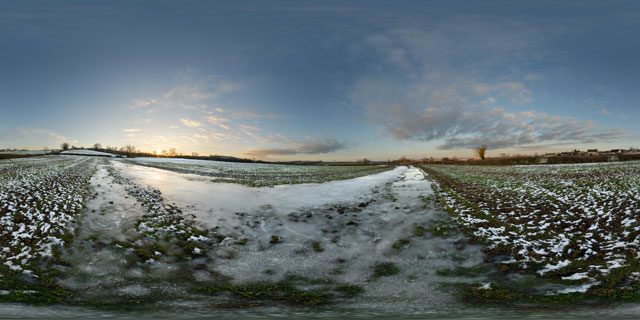
Click button below to view 360° VR interactive panorama
SD Standard definition suitable for users with slow internet connections or mobile devices or HD High definition suitable for users with fast internet connections
360° VR panorama of a large frozen puddle in a field near East Farndon, in Northamptonshire, England.

Click button below to view 360° VR interactive panorama
SD Standard definition suitable for users with slow internet connections or mobile devices or HD High definition suitable for users with fast internet connections
360° VR panorama of a snowy field just off Lubenham Road, near East Farndon, in Northamptonshire, England.
Many parts of the UK received heavy snowfall in late November / early December 2010, but the North Northamptonshire and south Leicestershire area got off with only a few centimetres of snow.

Click button below to view 360° VR interactive panorama
SD Standard definition suitable for users with slow internet connections or mobile devices or HD High definition suitable for users with fast internet connections
360° VR panorama of a snowy field at twilight between the Leicestershire town of Market Harborough and village of Lubenham, though technically located in Northamptonshire.
Many parts of the UK were hit by heavy snow in late November and early December 2010, though the North Northamptonshire and South Leicestershire area only received a few centimetres.

Click button below to view 360° VR interactive panorama
SD Standard definition suitable for users with slow internet connections or mobile devices or HD High definition suitable for users with fast internet connections
360° VR panorama of the sunset over a snowy field between Lubenham and Market Harborough in December 2010.
Much of the UK was hit with heavy snow in late November and early December 2010, though South Leicestershire / North Northamptonshire came off relatively lightly with only a few centimetres.

Click button below to view 360° VR interactive panorama
SD Standard definition suitable for users with slow internet connections or mobile devices or HD High definition suitable for users with fast internet connections
360° VR panorama of the sunset over a field in Farndon Fields, Market Harborough, England. Farndon Fields is currently (November 2010) being developed for housing.

Click button below to view 360° VR interactive panorama
SD Standard definition suitable for users with slow internet connections or mobile devices or HD High definition suitable for users with fast internet connections
360° VR panorama of the sunset over Farndon Fields in Market Harborough, Leicestershire, UK. Farndon Fields is currently (October 2010) being developed for housing by David Wilson Homes.

Click button below to view 360° VR interactive panorama
SD Standard definition suitable for users with slow internet connections or mobile devices or HD High definition suitable for users with fast internet connections
360° VR panorama of the sunset over a field just north of East Farndon, near Market Harborough, and around the border between Leicestershire and Northamptonshire, UK. The oak trees and hedge running along the edge of the field have turned yellow as the Autumn colour peaks.

Click button below to view 360° VR interactive panorama
SD Standard definition suitable for users with slow internet connections or mobile devices or HD High definition suitable for users with fast internet connections
360° VR panorama taken shortly after sunrise from the footpath across Farndon Fields in Market Harborough, Leicestershire, UK. Farndon Fields is currently (October 2010) being developed for housing by David Wilson Homes.


Click button below to view 360° VR interactive panorama
SD Standard definition suitable for users with slow internet connections or mobile devices or HD High definition suitable for users with fast internet connections
360° panorama of the sunset over a field of wheat between Market Harborough and East Farndon, Leicestershire, UK.
In the UK around 15 million tonnes of wheat is harvested annually, at a rate of approximately 8 tonnes per hectare.
From Wikipedia:
Wheat (Triticum spp.) is a grass, originally from the Fertile Crescent region of the Near East, but now cultivated worldwide. In 2007 world production of wheat was 607 million tons, making it the third most-produced cereal after maize (784 million tons) and rice (651 million tons). Globally, wheat is the leading source of vegetable protein in human food, having a higher protein content than either maize (corn) or rice, the other major cereals. In terms of total production tonnages used for food, it is currently second to rice as the main human food crop, and ahead of maize, after allowing for maize’s more extensive use in animal feeds.

Click button below to view 360° VR interactive panorama
SD Standard definition suitable for users with slow internet connections or mobile devices or HD High definition suitable for users with fast internet connections
360° VR panorama of the sunset over a fallow field between Market Harborough and East Farndon in Leicestershire, UK. The field has been subject to various development proposals over the years, and is currently (as of 2010) for sale as residential development land by its owner, CJC Devlopments Co. Ltd.


